Michael Baker
Expert Image Interpretation and Regional Studies
Landscape Intelligence
mike@mcwbaker.com
OIL & GAS
My services for hydrocarbon exploration are:
HOME
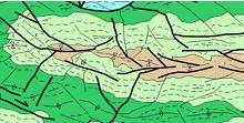
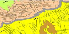
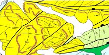
accurate interpretation of satellite imagery (including radar) and airphotos, from regional studies to local
integrated interpretation of satellite and geophysical imagery
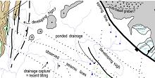
fracture mapping and interpretation of neotectonic movements
spectral, geomorphic and vegetation anomalies indicative of hydrocarbon seepage on land
regolith and landscape hazard mapping for seismic route planning
Experienced interpreter of vegetated terrains.
MINERALS
OIL & GAS
regional interpretation
detailed structure/fractures
WATER
mapping key horizons
evidence for neotectonism
LANDSCAPE
EXPERIENCE