mike@mcwbaker.com
Michael Baker
Expert Image Interpretation and Regional Studies
Landscape Intelligence
mike@mcwbaker.com
MINERALS
Accelerating Discoveries
HOME
My services for mineral exploration focus on enabling explorers to understand the geology of their prospects and the controls on mineralisation.
interpretation of satellite imagery (including radar) and airphotos, at resolutions from 80m to <1m
integrated interpretation of satellite and geophysical imagery
geological interpretation of spectral alteration anomalies
regolith mapping
Experienced interpreter of vegetated terrains.
MINERALS
OIL & GAS
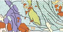
regional interpretation
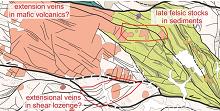
structure/targets from Aster
WATER
or airphotos
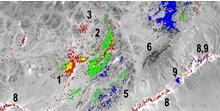
spectral targets from Aster
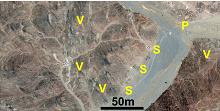
high resolution mapping
LANDSCAPE
EXPERIENCE